Hierarchy
county
barony
civil parish
townland
townland
Rahona West
(English)
Centrepoint
52.5941, -9.72949latitude, longitude
Irish Grid (with letter)
Computing...
Irish Grid (without letter)
Computing...
Irish Transverse Mercator (ITM)
Computing...
Archival records

Historical references
| 1623 |
Carrigahowla alias Runkenderrig alias the 2 Raahanaghes
|
CPR Leathanach: 553a
|
| 1624c |
North rahoone
|
Inq.(Cl) Leathanach: 2.29
|
| 1624 |
Northrahowne
Jac. I
|
Inq.(Cl) Leathanach: 2.29
|
| 1657 |
east Rahoone
|
|
| 1657 |
Rahoane west
|
|
| c.1660 |
Rahoane West
|
BSD (Cl) Leathanach: 398
|
| c.1660 |
Rahoine
|
BSD (Cl) Leathanach: 397
|
| 1666 |
Rathona
|
ASE Leathanach: 87 §18
|
| 1685 |
Rahoone
|
|
| 1685 |
Rahoone
|
|
| 1694 |
Rath[]ony East et West
G. & M.
|
Inq.(Cl) Leathanach: 1.245
|
| 1694 |
Rathona
G. & M.
|
Inq.(Cl) Leathanach: 1.286
|
| c.1695 |
Rathona
|
Inq.(Cl) Leathanach: 1.286
|
| 1703 |
Rathony alias Rahony west
|
Forf. Est. Leathanach: 353 §1
|
| 1703 |
Rathrony alias Rahony east
|
Forf. Est. Leathanach: 353 §1
|
| 1787 |
Rahoan Ho.
|
|
| 1839 |
Rahoona West
|
BS:AL Leathanach: Cl111,27
|
| 1839 |
Rahonas West
|
Map of Property 1835:AL Leathanach: Cl111,27
|
| 1839 |
Rahone West
|
Cess Coll.:AL Leathanach: Cl111,27
|
| 1839 |
Rahona West
|
Duggan, Rev. M.:AL Leathanach: Cl111,27
|
| 1839 |
Rahona West
|
Local:AL Leathanach: Cl111,27
|
| 1839 |
Rahona West
|
Tithe Ledger:AL Leathanach: Cl111,27
|
| 1839 |
Rahona West
|
Co. Bk.:AL Leathanach: Cl111,27
|
| 1839 |
Rathony West
|
Inq. G. & M.:AL Leathanach: Cl111,27
|
| 1839 |
[Rahona West]
"Antiquities, 6 forts" [Desc. Rem.];
|
Desc. Rem.:AL Leathanach: Cl111,27
|
| 1839 |
Rahoona East
|
BS:AL Leathanach: Cl111,26
|
| 1839 |
Rahone West
|
Cess Coll.:AL Leathanach: Cl111,26
|
| 1839 |
Rahoan
|
CM:AL Leathanach: Cl111,26
|
| 1839 |
Rahona East
|
Co. Bk.:AL Leathanach: Cl111,26
|
| 1839 |
[Rahona East]
|
Desc. Rem.:AL Leathanach: Cl111,26
|
| 1839 |
Rahona
|
Duggan, Rev. M.:AL Leathanach: Cl111,26
|
| 1839 |
Rathona
"Antiquities, 4 forts" [Desc. Rem.];
|
Inq. G. & M.:AL Leathanach: Cl111,26
|
| 1839 |
Rathony East
|
Inq. G. & M.:AL Leathanach: Cl111,26
|
| 1839 |
Rahona East
|
Local:AL Leathanach: Cl111,26
|
| 1839 |
Rahona
|
Map of Property 1714:AL Leathanach: Cl111,26
|
| 1839 |
Rahonas East
|
Map of Property 1835:AL Leathanach: Cl111,26
|
| 1839 |
Rahona &c
|
OD:AL Leathanach: Cl111,26
|
| 1839 |
Ráth Ona, 'Ona's fort'
|
OD:AL Leathanach: Cl111,26
|
| 1839 |
Rahona East
|
Tithe Ledger:AL Leathanach: Cl111,26
|
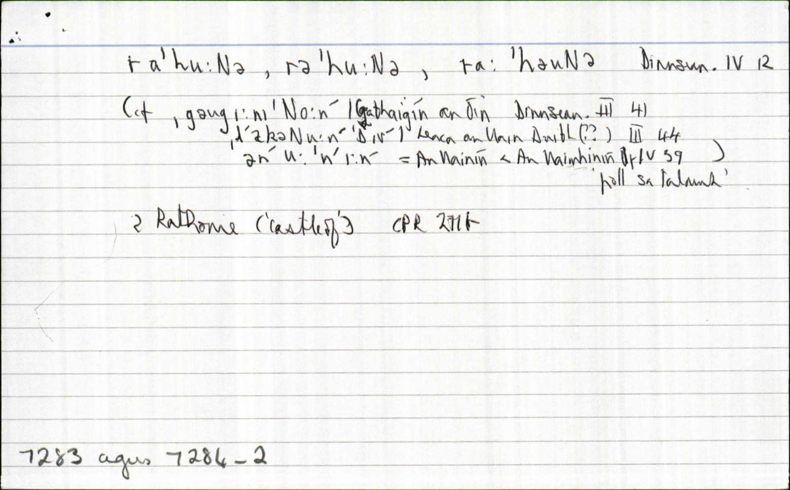
| 1965 |
rɑˈhuːɴə, rəˈhuːɴə, rɑːˈhəuɴə
|
Dinnseanchas Leathanach: 4.12
|
| 1965 |
[Rahona East]
bar Moyarta
|
Dinnseanchas Leathanach: 4.16n
|
Please note: Some of the documentation from the archives of the Placenames Branch is available here. It indicates the range of research contributions undertaken by the Branch on this placename over the years. It may not constitute a complete record, and evidence may not be sequenced on the basis of validity. It is on this basis that this material is made available to the public.
Archival and research material provided on this site may be used, subject to acknowledgement. Issues regarding republication or other permissions or copyright should be addressed to logainm@dcu.ie.
Permanent link
https://www.logainm.ie/7284.aspxOpen data
Application programming interface (API)
Available under
Creative Commons Attribution 4.0 International (CC BY 4.0)
API key required to access data
Linked Logainm
Formats: RDF | RDF N3 | RDF JSON | RDF XML
Operated by Digital Repository of Ireland