Hierarchy
county
barony
civil parish
townland
townland
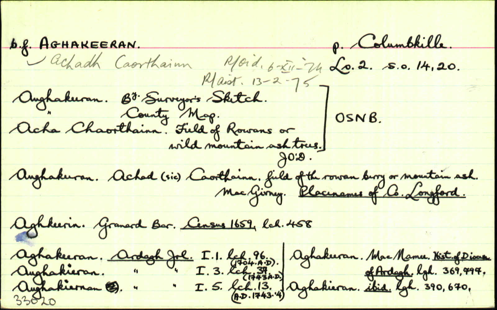
Achadh Caorthainn
genitive: Achadh Caorthainn
(Irish)
Aghakeeran
(English)
Hierarchy
county
barony
civil parish
Centrepoint
53.8164, -7.60082latitude, longitude
Irish Grid (with letter)
Computing...
Irish Grid (without letter)
Computing...
Irish Transverse Mercator (ITM)
Computing...
Archival records
Historical references
| 1612 |
Aghechirine
|
Inq. Lag. Leathanach: 3 Jac.1
|
| 1629 |
Aghnekerin
suíomh beagán mícheart ?
|
|
| 1655 |
Aghakirrill
|
|
| 1659 |
Aghkeerin
|
|
| c.1660 |
Aghakirrill
|
BSD Leathanach: 165
|
| 1667 |
Aghacorrin als Aghakirrell
|
ASE Leathanach: 145
|
| 1685 |
Aghkiruell
|
|
| 1711 |
Ahekeerin
|
CGn. Leathanach: 5.419.2394
|
| 1813 |
Aughakeeran
|
|
| 1836 |
Aughakeeran
|
|
| 1836 |
Aughakeiron
|
|
| 1836 |
Acha Chaorthainn, “field of Rowans or wild mountain ash trees”
|
|
| 1836 |
Acha caorthain
|
|
| 1836 |
...nearly 1/3 of this townland is under Bog...
|
|
| 1908 |
Achadh Caorthainn, “field of the rowan berry or mountain ash”
|
MacGivney Leathanach: 20
|
| 1975 |
Achadh Caorthainn [fch. mo nóta thíos]
|
|
| 2007 |
ɑhəˈkiːrnən
|
Please note: Some of the documentation from the archives of the Placenames Branch is available here. It indicates the range of research contributions undertaken by the Branch on this placename over the years. It may not constitute a complete record, and evidence may not be sequenced on the basis of validity. It is on this basis that this material is made available to the public.
Archival and research material provided on this site may be used, subject to acknowledgement. Issues regarding republication or other permissions or copyright should be addressed to logainm@dcu.ie.
Permanent link
https://www.logainm.ie/33020.aspxOpen data
Application programming interface (API)
Available under
Creative Commons Attribution 4.0 International (CC BY 4.0)
API key required to access data
Linked Logainm
Formats: RDF | RDF N3 | RDF JSON | RDF XML
Operated by Digital Repository of Ireland